Hurricane Erin: Unpacking the Record-Breaking Atlantic Storm
When most people think of hurricanes, they imagine destructive winds tearing through coastal cities, leaving devastation in their wake. But not all hurricanes follow that script. Some storms, despite never making landfall, leave a deep mark on science, coastal safety, and even wildlife. Hurricane Erin is one of those rare storms.
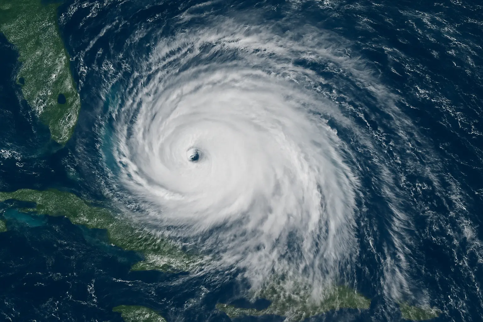
In August 2025, Hurricane Erin transformed from a tropical wave into a monstrous Category 5 cyclone in less than 24 hours. Even though it stayed offshore, Erin generated towering waves, flooding rains, and widespread ecological damage. It also left meteorologists stunned at its rapid growth and sheer size—more than 500 miles across, making it one of the largest Atlantic storms in history.
In this comprehensive guide, we’ll break down Hurricane Erin’s origins, its explosive intensification, its impact on communities and ecosystems, and what it teaches us about climate change and hurricane preparedness.

Table of Contents
The Birth of Hurricane Erin
Every major storm begins as something small. In Erin’s case, it started as a tropical wave off the coast of Africa near Cape Verde on August 11, 2025. These types of systems are sometimes called Cape Verde hurricanes because they often grow into powerful storms after leaving West Africa, traveling across the warm waters of the Atlantic.
Within just a few hours of formation, Erin brought torrential rain to Cape Verde. The islands saw flash flooding, landslides, and tragic fatalities. According to reports, nine people were killed on São Vicente, while two others went missing. Entire neighborhoods were overwhelmed in just five hours of rainfall, prompting a national disaster declaration by Cape Verdean officials.
From the very beginning, Hurricane Erin demonstrated its ability to cause destruction even in its earliest stage—an ominous signal of what was to come.
Explosive Intensification & Record Category 5 Strength
By August 15, Erin had strengthened into a Category 1 hurricane. What shocked scientists was what happened next. In less than a single day, Erin’s winds exploded from tropical-storm force (≈70 mph) to a Category 5 monster with 160 mph winds. Its central pressure plummeted to around 915 millibars—a signature of extreme intensity.
Meteorologists call this phenomenon rapid intensification, which is defined as a storm strengthening by at least 35 mph in 24 hours. Erin blew past that threshold, gaining nearly 90 mph in less than a day. Lightning storms erupted in its eyewall, a visual signal of the storm’s explosive energy.
Scientists quickly linked this to record-warm Atlantic waters, which acted like jet fuel for Erin. Climate experts noted that Category 4–5 hurricanes are now five times more likely than they were in the 1980s. Erin became a textbook example of how climate change is rewriting hurricane behavior—stronger, faster, and harder to predict.
A Giant Among Hurricanes: Scale & Size
Most hurricanes have wind fields that stretch 100–200 miles. Erin dwarfed that. At its peak, the storm’s tropical-storm-force winds extended over 500 miles across—roughly the distance from New York City to Charlotte, North Carolina.
This placed Erin in the largest 10% of all Atlantic hurricanes ever recorded. Even after weakening below Category 5, the storm maintained an enormous footprint, with waves and winds reaching communities hundreds of miles away.
Imagine standing on a beach in New Jersey with blue skies overhead—yet watching 20-foot waves crash ashore. That was the paradox of Hurricane Erin. Its size meant it behaved more like a moving weather continent than a typical storm.
Coastal Impacts: Surf, Rip Currents & Flooding
Even without making landfall, Hurricane Erin battered the U.S. East Coast. From the Carolinas to New England, beaches were shut down as rip currents dragged swimmers away from shore.
- North Carolina: The Outer Banks issued a state of emergency. On Hatteras Island, Highway 12 was overwashed by the ocean, cutting off entire communities. Lifeguards performed rescues as inexperienced swimmers were caught in powerful riptides.
- New Jersey & Delaware: Cities like Ocean City and Sea Isle City experienced flooded streets and restaurant evacuations. Emergency responders rescued dozens of people trapped in vehicles.
- New York & Long Island: Beaches like Coney Island, Rockaway, and Jones Beach closed, despite the sunny weather. Officials warned that waves could reach 10 feet or higher—deadly conditions for anyone entering the water.
This highlights a crucial lesson: a hurricane doesn’t need to make landfall to be life-threatening. Erin’s sheer size meant its effects radiated outward like ripples in a pond, touching communities far beyond its core.
Ecological Toll: Sea Turtle Nest Destruction
One of the most heartbreaking effects of Hurricane Erin was its impact on endangered sea turtles. The timing of the storm coincided with the nesting season for loggerhead turtles on the barrier islands of North Carolina.
- On Topsail Island, more than half of 43 nests were washed away.
- On Emerald Isle, 8 out of 10 remaining nests were destroyed by high waves.
Each nest contains around 100 eggs, meaning thousands of hatchlings were lost in just a few hours. While marine biologists note that turtle populations can recover over time, the emotional toll on volunteers—who had monitored and protected these nests for weeks—was immense.
As one conservationist put it: “You spend every day guarding life, and in a single tide, it’s gone.” Hurricane Erin was a stark reminder that storms impact more than human infrastructure—they can reshape ecosystems in minutes.
Global Ripple Effects & Weather Pattern Disruptions
Hurricane Erin didn’t just affect the Atlantic coast. Its massive circulation influenced weather thousands of miles away.
As it transitioned into a post-tropical cyclone on August 22, Erin’s remnants were pulled into the jet stream, sending ripple effects toward Europe and the United Kingdom. Meteorologists noted that Erin disrupted moisture flows, creating unusual patterns such as bank-holiday heatwaves in southern England and stormy rains in northern regions.
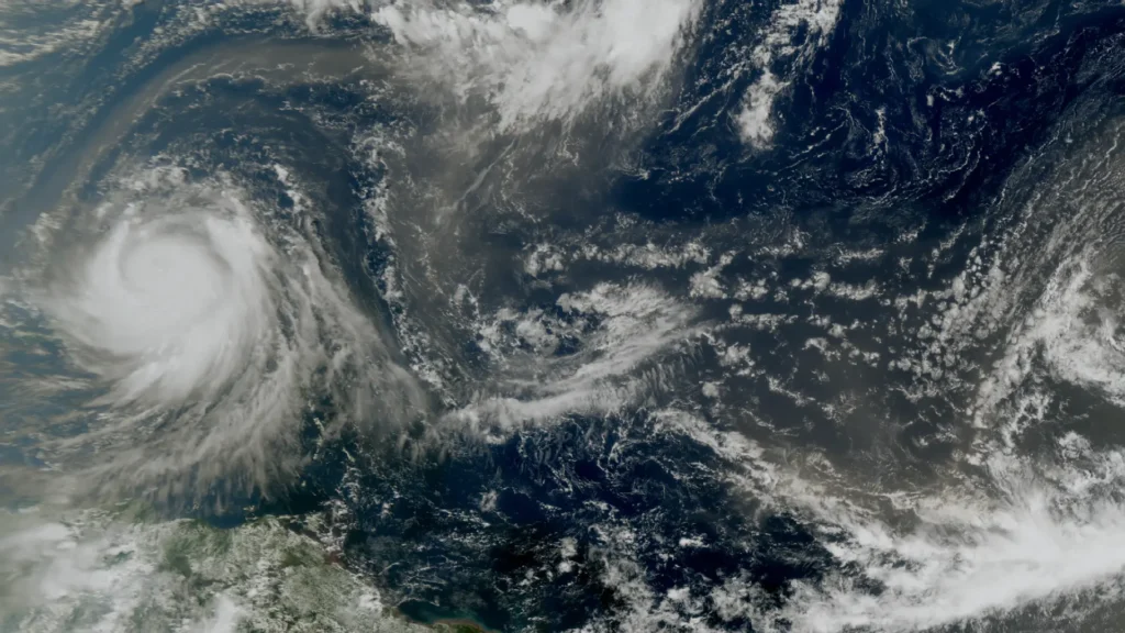
Satellite images captured Erin as a swirling giant, reshaping cloud formations across the Atlantic. NASA’s Earth Observatory compared its energy release to several hundred nuclear bombs detonating per day, emphasizing the sheer power of tropical systems.
Emergency Preparedness: Lessons from Erin
Erin taught a tough lesson: offshore storms can still be deadly. Emergency planners in Florida and the Carolinas admitted that public messaging often focuses only on landfalling hurricanes. But Erin forced a mindset shift.
Florida’s emergency director remarked: “It’s no longer a question of if—we need to prepare as though a hurricane will affect us every year.”
Key takeaways for preparedness included:
- Broader evacuation zones for barrier islands.
- Early beach closures before rip currents peak.
- Public education campaigns stressing that sunshine doesn’t equal safety when a storm looms offshore.
Historical Context: Other Storms Named Erin
Hurricane names repeat every six years unless retired. Erin is no stranger to history:
- 1995 Erin: Category 2 hurricane, struck Florida twice, caused $700 million in damage and 16 deaths.
- 2001 Erin: Category 3, passed east of Bermuda, produced high surf but little damage.
- 2019 Erin: Tropical storm that brought flooding to Nova Scotia.
The 2025 version, however, dwarfed them all. Not only was it the first major hurricane of the season, but it also became a Category 5 giant that may be remembered as one of the most unusual storms of the decade.
Forecasting & Climate Change Implications
Erin’s rapid intensification raised alarms in the meteorological community. Forecast models had underestimated its strength, leaving officials scrambling to update advisories.
Scientists point to rising ocean heat content as a primary factor. The Atlantic in August 2025 recorded record-high sea surface temperatures, fueling Erin’s explosive growth. Warmer waters don’t just strengthen hurricanes—they expand their potential size, helping explain Erin’s 500-mile reach.
Climate experts warn that storms like Erin are a preview of the future. The world may see fewer total storms, but a higher proportion of them will be Category 4 or 5 monsters.
Actionable Takeaways for Coastal Residents
Hurricane Erin’s story offers practical lessons for anyone living near the ocean:
- Don’t rely on landfall predictions. Offshore hurricanes can still cause deadly surf and flooding.
- Respect beach closures. If officials say stay out of the water, it’s for your safety—not convenience.
- Protect ecosystems. Support turtle patrols, dune preservation, and marshlands that act as natural storm buffers.
- Prepare annually. Hurricane kits, evacuation plans, and communication strategies should be updated every season.
- Stay informed. Follow local emergency services, not just national news. Hazards vary by community.
FAQs
What was Hurricane Erin?
Hurricane Erin was a tropical cyclone that struck in August 1995, becoming the first hurricane of that Atlantic season. It impacted Florida, Alabama, and parts of the U.S. East Coast, causing flooding, power outages, and significant property damage.
When did Hurricane Erin make landfall?
Hurricane Erin made two landfalls in Florida—first on August 2, 1995, near Vero Beach on the east coast, and later the same day on the Florida Panhandle near Pensacola.
How strong was Hurricane Erin at its peak?
At its peak, Hurricane Erin reached Category 2 strength on the Saffir-Simpson Hurricane Wind Scale, with sustained winds of around 100 mph (160 km/h).
How many people died during Hurricane Erin?
Hurricane Erin caused 13 fatalities (indirect and direct combined), mostly due to accidents, flooding, and storm-related incidents.
How much damage did Hurricane Erin cause?
Hurricane Erin caused an estimated $700 million USD in damages, including destruction of homes, coastal infrastructure, power lines, and agricultural losses across Florida and nearby states.
Did Hurricane Erin affect the space shuttle program at Cape Canaveral?
Yes. NASA’s Kennedy Space Center in Cape Canaveral had to shut down operations temporarily as Erin passed directly over the area. Some minor damage occurred, but no spacecraft were harmed.
Was Hurricane Erin connected to the Bermuda Triangle or conspiracy theories?
While some conspiracy theories circulated online, including claims about Hurricane Erin’s unusual path and timing, there is no scientific evidence linking Erin to anything beyond natural weather patterns.
How did Hurricane Erin compare to other hurricanes in Florida’s history?
Erin was not as destructive as Hurricane Andrew (1992) or later storms like Hurricane Irma (2017), but it was still significant because it struck Florida twice in one day, affecting both coasts.
What lessons were learned from Hurricane Erin?
Hurricane Erin reinforced the importance of early hurricane preparedness, evacuation planning, stronger building codes, and public awareness campaigns in Florida.
Could another storm like Hurricane Erin happen again?
Yes. With ongoing climate change, warmer ocean waters, and shifting weather patterns, Florida and the U.S. East Coast remain highly vulnerable to hurricanes similar to Erin. Meteorologists stress the importance of preparedness every hurricane season.


In today’s fast-paced world, many seek ways to simplify life’s necessities.Contact us now to Buy drivers License . If you need a quick and efficient solution, consider the option to buy driver’s license online. This method offers unparalleled convenience. When you purchase driver’s license, you save valuable time and avoid bureaucratic red tape. Moreover, a legal driver’s license buy ensures you are compliant with regulations, providing peace of mind. For those in a hurry, get driver’s license fast is the optimal choice. Simply order driver’s license and experience the ease of having a driver’s license for sale at your fingertips. Embrace this modern solution today.
If you have been in need of AUTHENTIC traveling documents, we are here to let you know that you now have a lasting solution to your long time search. ( https://buyauthenticdocument.com ). Here, we produce and deliver REGISTERED documents within 7 to 10 working days across the GLOBE. Our services are supper fast and reliable. For more information, kindly click on the link bellow to see more information about the services we offer.
Szukasz zarejestrowanych i legalnych dokumentów online? Nie szukaj dalej. Continental Documents Ci pomoże (https://continentaldocuments.com )